
FALLS CREEK
(www.northeastvictoria.online - smartphone site)
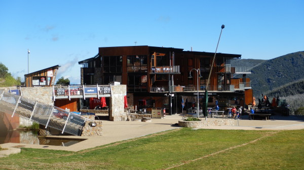
Falls Creek is the typical Australian alpine village - a mix of rustic chalets, the steel and concrete moderns, and the ubiquitous snowgum woodland.
Driving up from Mount Beauty, the village comes into view shortly after Howmans Gap (at about the 32km mark from Mount Beauty) and is accompanied by an abrupt change in vegetation, mountain ash and alpine ash forests giving way to that snowgum woodland (alternative access is via the Mitta Mitta Valley from the south)..
The village is very busy during the snow season, and whilst but things go a little quieter during the warmer months, this is a very successful all-seasons venue - a great place to spend an active holiday.
Things to do include bushwalking, mountain biking, boating (on Rocky Valley Dam) and sightseeing.
The village has a supermarket, cafes, bars and restaurants, and there is a wide range of accommodation on offer.
The first ski accommodation in the Falls Creek area was right on the Bogong High Plains, and not in the present comparatively sheltered location.
Cope Hut (built in the late 1920s) was one of the first ski accommodations in the area, whereas the village itself has its origin in a project by the Ski Club of Victoria to build a War Memorial clubhouse, with access to reasonably steep slopes for downhill skiing, and undulating terrain for cross-country skiing.
The site chosen was in the Ruined Castle area, north of the present day ski-village, however construction works for the Kiewa Hydro-electric Scheme precluded use of this site for several years, and in 1946 an alternative site between Frying Pan Spur and Ruined Castle Spur was selected.
Construction soon began, and by 1960 Falls Creek could offer all the comforts of the high life.
The resort has a well integrated, and extensive, array of ski-lifts for downhill skiers, and the Bogong High Plains, with its impressive cross-country ski trails, and bushwalking tracks, adjoins the village.
See the descriptions listed below for details of bushwalking venues, sightseeing etc.
If you can find a copy, The Kiewa Story by Graham Napier and Geoff Easdown has a detailed account of the Kiewa Project.
Packhorse Heritage Trail
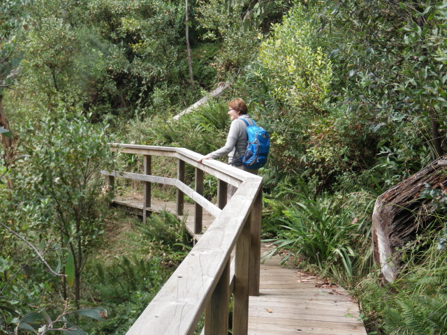
The Packhorse Heritage Trail [AWTGS-2] leads from Howmans Gap to Falls Creek Village, utilising a former packhorse trail that cattlemen once used to access the Bogong High Plains.
This is a four kilometre walk, and takes about 90 minutes each way - it leads into Falls Creek Village, just near Gully Carpark.
[Another item of interest in this area, is to walk from the accommodation complex down to Rocky Valley Stream (the scenic waterway that notionally flows out of Rocky Valley Dam; this is a very scenic alpine stream, with crystal clear water and endless cascades).
Check in with management at Howmans Gap, and then follow the signage down to Rocky Valley Stream (quite steep, but well engineered).
Once at the stream frontage, it’s time for morning/afternoon tea, and then to face the music, and head back uphill.
Allow about 90 minutes for this AWTGS-3 foray, and take care on the single file sections.]
Falls Creek Aqueduct
The aqueduct was built as part of the water supply for the original village, and traps, and transports, water from several natural springs on the hillslopes above the village.

This is a there and back walk, and there are several access points from near the upper part of the village, notably Schuss Street and Parallel Street.
In both cases, a short slope leads to a nicely maintained gravel path that curves around the southern, and western, slopes above the village.
There are many great views to enjoy, not only of the village, but also the high country beyond.
The trail covers about three kilometres, and on the west side finishes where the steep trail known as "Home and Away" heads off to the left; on the south side it finishes at the bitumen of the Bogong High Plains Road.
It's possible to follow the continuation of the aqueduct walk on the south side - by carefully crossing the High Plains Road.
This leads down to the lower parts of the Rocky Valley Dam, and thence to the start of the Roper's Lookout Track.
In either direction, the aqueduct is a popular walking/jogging track, and is rated as AWTGS-2.
BOGONG ALPINE WAY (Bright - Mount Beauty - Falls Creek - Omeo - Mount Hotham - Bright)
KIEWA VALLEY HIGHWAY (Albury-Wodonga, Kergunyah, Mount Beauty)
MOUNT BEAUTY to OMEO (via Bogong Village, Falls Creek and Bogong High Plains)
Falls Creek Information Centre
COPYRIGHT © 1995-2023, Chris McLaughlin.